I wish they were closer, but from the photos we can definitely see that the Uptown area of New Orleans where Tulane University (and hubby's office) is located appears to be in the 20% of the city that isn't under water at the moment (I suppose that can change if they don't get that levee plugged though. Also, the area for our neighborhood appears to be in the area in Slidell that doesn't currently have standing water. This is good news. Of course, there is no easy way to get from home to work anymore. I need to see what the condition of the Causeway Bridge is.
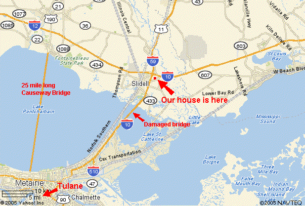
I know my family and friends are trying to figure out exactly where we live in relation to all the horror, so for a reference, here is a map of Slidell which I have marked to show the location of our house and where Hubby works. (Click to enlarge it)
2 comments:
I created an animated gif, combining Google Satellite with the NASA before and after pics, so you can more easily find stuff and see the change. It's here.
Laurel,
I found pics of Slidell at this Christian Science Monitor site
http://www.csmonitor.com/slideshows/katrina05/slide1.html
Know all our good thoughts are going to you and your family.
Much love,
Kathleen and Matt
Post a Comment